Select your language

pdf Relative Sea-Level Rise Scenario for 2100 along the Coast of South Eastern Sicily (Italy) by InSAR Data, Satellite Images and High-Resolution Topography

In Publications that have benefited from savemedcoasts projects 403 downloads

Summary

The global sea-level rise (SLR) projections for the next few decades are the basis for developing flooding maps that depict the expected hazard scenarios. However, the spatially variable land subsidence has generally not been considered in the current projections. In this study, we use geodetic data from global navigation satellite system (GNSS), synthetic aperture radar interferometric measurements (InSAR) and sea-level data from tidal stations to show the combined effects of land subsidence and SLR along the coast between Catania and Marzamemi, in south-eastern Sicily (southern Italy). This is one of the most active tectonic areas of the Mediterranean basin, which drives accelerated SLR, continuous coastal retreat and increasing effects of flooding and storms surges. We focus on six selected areas, which show valuable coastal infrastructures and natural reserves where the expected SLR in the next few years could be a potential cause of significant land flooding and morphological changes of the coastal strip. Through a multidisciplinary study, the multi-temporal flooding scenarios until 2100, have been estimated. Results are based on the spatially variable rates of vertical land movements (VLM), the topographic features of the area provided by airborne Light Detection And Ranging (LiDAR) data and the Intergovernmental Panel on Climate Change (IPCC) projections of SLR in the Representative Concentration Pathways RCP 2.6 and RCP 8.5 emission scenarios. In addition, from the analysis of the time series of optical satellite images, a coastal retreat up to 70 m has been observed at the Ciane river mouth (Siracusa) in the time span 2001–2019. Our results show a diffuse land subsidence locally exceeding 10 ± 2.5 mm/year in some areas, due to compacting artificial landfill, salt marshes and Holocene soft deposits. Given ongoing land subsidence, a high end of RSLR in the RCP 8.5 at 0.52 ± 0.05 m and 1.52 ± 0.13 m is expected for 2050 AD and 2100 AD, respectively, with an exposed area of about 9.7 km2 that will be vulnerable to inundation in the next 80 years.

Figure

results publication5

The bay of Siracusa. In colors are reported the expected extension of land flooding in 2050 and 2100 for (a) RCP 2.6 and (b) RCP 8.5 climatic scenarios for a mean land subsidence at 7 ± 2.5 mm/year. The expected maximum loss of land is 2.378 km2

How to cite and download the publication:

Anzidei, M.; Scicchitano, G.; Scardino, G.; Bignami, C.; Tolomei, C.; Vecchio, A.; Serpelloni, E.; De Santis, V.; Monaco, C.; Milella, M.; et al. Relative Sea-Level Rise Scenario for 2100 along the Coast of South Eastern Sicily (Italy) by InSAR Data, Satellite Images and High-Resolution Topography. Remote Sens. 2021, 13, 1108. https://doi.org/10.3390/rs13061108

pdf The Impact of Future Sea-Level Rise on Low-Lying Subsiding Coasts: A Case Study of Tavoliere Delle Puglie (Southern Italy).

In Publications that have benefited from savemedcoasts projects 441 downloads

Abstract

Low-lying coastal zones are highly subject to coastal hazards as a result of sea-level rise enhanced by natural or anthropogenic land subsidence. A combined analysis using sea-level data and remote sensing techniques allows the estimation of the current rates of land subsidence and shoreline retreat, supporting the development of quantified relative sea-level projections and flood maps, which are appropriate for specific areas. This study focuses on the coastal plain of Tavoliere delle Puglie (Apulia, Southern Italy), facing the Adriatic Sea. In this area, land subsidence is mainly caused by long-term tectonic movements and sediment compaction driven by high anthropogenic pressure, such as groundwater exploitation and constructions of buildings. To assess the expected effects of relative sea-level rise for the next decades, we considered the following multidisciplinary source data: (i) sea-level-rise projections for different climatic scenarios, as reported in the Sixth Assessment Report of the Intergovernmental Panel on Climate Change, (ii) coastal topography from airborne and terrestrial LiDAR data, (iii) Vertical Land Movement (VLM) from the analysis of InSAR and GNSS data, and (iv) shoreline changes obtained from the analysis of orthophotos, historic maps, and satellite images. To assess the expected evolution of the coastal belt, the topographic data were corrected for VLM values, assuming that the rates of land subsidence will remain constant up to 2150. The sea-level-rise projections and expected flooded areas were estimated for the Shared Socioeconomic Pathways SSP1-2.6 and SSP5-8.5, corresponding to low and high greenhouse-gas concentrations, respectively. From our analysis, we estimate that in 2050, 2100, and 2150, up to 50.5 km2, 118.7 km2 and 147.7 km2 of the coast could be submerged, respectively, while beaches could retreat at rates of up to 5.8 m/yr. In this area, sea-level rise will be accelerated by natural and anthropogenic land subsidence at rates of up to −7.5 ± 1.7 mm/yr. Local infrastructure and residential areas are thus highly exposed to an increasing risk of severe inundation by storm surges and sea-level rise in the next decades.

Figure

results publication6

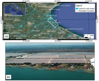
The coastal plain of Tavoliere delle Puglie: (a) geographic map of the coastal plain; (b) aerial photograph of the salt marshes located in the Zapponeta area with defenses built along the coast.

How to cite and download the publication:

Scardino, G.; Anzidei, M.; Petio, P.; Serpelloni, E.; De Santis, V.; Rizzo, A.; Liso, S.I.; Zingaro, M.; Capolongo, D.; Vecchio, A.; et al. The Impact of Future Sea-Level Rise on Low-Lying Subsiding Coasts: A Case Study of Tavoliere Delle Puglie (Southern Italy). Remote Sens. 2022, 14, 4936. https://doi.org/10.3390/rs14194936

pdf Dynamical diagnostic of extreme events in Venice lagoon and their mitigation with the MoSE

In Publications that have benefited from savemedcoasts projects 456 downloads

Summary

Extreme events are becoming more frequent due to anthropogenic climate change, posing serious concerns on societal and economic impacts and asking for mitigating strategies, as for Venice. Here we proposed a dynamical diagnostic of Extreme Sea Level (ESL) events in the Venice lagoon by using two indicators based on combining extreme value theory and dynamical systems: the instantaneous dimension and the inverse persistence. We show that the latter allows us to localize ESL events with respect to sea level fluctuations around the astronomical tide, while the former informs us on the role of active processes across the lagoon and specifically on the constructive interference of atmospheric contributions with the astronomical tide. We further examined the capability of the MoSE (Experimental Electromechanical Module), a safeguarding system recently put into operation, in mitigating extreme flooding events in relation with the values of the two dynamical indicators. We show that the MoSE acts on the inverse persistence in reducing/controlling the amplitude of sea level fluctuation and provide a valuable support for mitigating ESL events if operating, in a full operational mode, at least several hours before the occurrence an event.

Figure

results publication7

The geographical location of the 4 selected tide gauge stations (filled white circles) across the Venice lagoon (Chioggia Cittá-Vigo, Malamocco Porto, Punta della Salute Giudecca, and Laguna Nord Saline) together with the three MoSE inlets. The map has been produced with Google Earth.


How to cite and download the publication:

Alberti, T., Anzidei, M., Faranda, D. et al. Dynamical diagnostic of extreme events in Venice lagoon and their mitigation with the MoSE. Sci Rep 13, 10475 (2023). https://doi.org/10.1038/s41598-023-36816-8

pdf Sea level rise scenario for 2100 A.D. for the archaeological site of Motya

In Publications that have benefited from savemedcoasts projects 444 downloads

Abstract

In this study, we analyze the impact of the sea level rise induced by climate change on the coastal cultural heritage site of Motya, the Phoenician colony (IV–III millennium B.P.) located in the San Pantaleo island, NW corner of Sicily (southern Italy). In particular, we assessed the effects of this phenomenon on the human settlement in the past 2400 years and the expected sea level rise scenario for the next decades. A detailed flooding scenario for 2100 from direct observations and two models, taking into account the contribution of Vertical Land Movements (VLM), is provided. The surface topography is derived from a novel high-resolution/high-accuracy digital surface model (DSM), which was performed through an Unmanned Aerial Vehicles (UAV) survey, whereas the rate of VLM was estimated by the analysis of geodetic data at three Continuous Global Positioning System (CGPS) stations located close to the island. To estimate the local mean sea level and to correct the tide level (TL) at the epoch of UAV survey, the hydrometric recordings of the nearest sea level gauge station located at Porto Empedocle (Sicily), were used. Two flooding scenarios for 2100 were then represented on the high-resolution DSM, using the regional sea-level projections of the International Panel on Climate Change (IPCC) for the Mediterranean region. According to the RCP 8.5 climatic model, a difference of about + 59 cm above the local mean sea level between the current and the expected coastline positions at 2100 A.D., was found. In addition, by adding the average half amplitude of the daily tide, equal to about 30 cm, a maximum flooding scenario was determined. Finally, in the maximum condition of sea level rise, a significant flooding on the archaeological structures is expected for the Kothon area and along the North-West coast of the island.

Figure

results publication8

Location of Mothya

How to cite and download the publication:

Ravanelli, R., Riguzzi, F., Anzidei, M. et al. Sea level rise scenario for 2100 A.D. for the archaeological site of Motya. Rend. Fis. Acc. Lincei 30, 747–757 (2019). https://doi.org/10.1007/s12210-019-00835-3

pdf Relative Sea-Level Rise Projections and Flooding Scenarios for 2150 CE for the Island of Ustica (Southern Tyrrhenian Sea, Italy).

In Publications that have benefited from savemedcoasts projects 423 downloads

Summary

The island of Ustica (Italy) is constantly exposed to the effects of sea-level rise, which is threatening its coastal zone. With the aim of assessing the sea levels that are anticipated by 2150 CE under the climatic projections shown in the AR6 report from the IPCC, a detailed evaluation of potential coastal flooding under different climatic scenarios and the ongoing land subsidence has been carried out for three coastal zones. Scenarios are based on the determination of the current coastline position, a high-resolution digital terrain and marine model, and the SSP1-2.6, SSP3-7.0, and SSP5-8.5 climatic projections. Relative sea-level rise projections allowed the mapping of the potential inundated surfaces for 2030, 2050, 2100, and 2150. The results show rising sea levels for 2150, ranging from a minimum of 66 ± 40 cm (IPCC AR6 SSP2.6 scenario) to a maximum of 128 ± 52 cm (IPCC AR6 SSP8.5 scenario). In such conditions, considering the SSP8.5 scenario during storm surges with return times (RTs) of 1 and 100 years, the expected maximum wave run-up along the island may vary from 3 m (RT = 1) to 14 m (RT = 100), according to the coastal morphology. Our results show that adaptation and mitigation actions are required to protect the touristic and harbor installations of the island.

Figure

results publication9

Potential submersion areas for Ustica Harbor, based on the current rates of VLM and the SSP5-8.5 climatic scenario up until 2150 (see Table S1 Figure 10a for flooded surfaces).

How to cite and download the publication

Anzidei, M.; Trippanera, D.; Bosman, A.; Martin, F.F.; Doumaz, F.; Vecchio, A.; Serpelloni, E.; Alberti, T.; Rende, S.F.; Greco, M. Relative Sea-Level Rise Projections and Flooding Scenarios for 2150 CE for the Island of Ustica (Southern Tyrrhenian Sea, Italy). J. Mar. Sci. Eng.2023, 11, 2013. https://doi.org/10.3390/jmse11102013

pdf Attributing Venice Acqua Alta events to a changing climate and evaluating the efficacy of MoSE adaptation strategy

In Publications that have benefited from savemedcoasts projects 339 downloads

Summary

We use analogues of atmospheric patterns to investigate changes in four devastating Acqua Alta (flooding) events in the lagoon of Venice associated with intense Mediterranean cyclones occurred in 1966, 2008, 2018 and 2019. Our results provide evidence that changes in atmospheric circulation, although not necessarily only anthropogenically driven, are linked to the severity of these events. We also evaluate the cost and benefit of the MoSE system, which was designed to protect against flooding. Our analysis shows that the MoSE has already provided protection against analogues of the most extreme event, which occurred in 1966. These findings have significant implications for the future of Venice and other coastal cities facing similar challenges from rising sea levels due to extreme events. This study also provides a pathway to evaluate the effectiveness of adaptation in a scenario more frequent and intense extreme events if higher global warming levels will be reached.

results publication n10

How to cite and download:

Faranda, D., Ginesta, M., Alberti, T., Coppola, E., Anzidei, M.Attributing Venice Acqua Alta events to a changing climate and evaluating the efficacy of MoSE adaptation strategy. n pj Clim Atmos Sci 6, 181 (2023). https://doi.org/10.1038/s41612-023-00513-0

pdf Coastal 3D mapping using very high resolution satellite images and UAV imagery: new insights from the SAVEMEDCOASTS project

In Publications that have benefited from savemedcoasts projects 350 downloads

Summary

Global climate changes are a main factor of risk for infrastructures and people living along the coasts around the world. In this context, sea level rise, coastal retreat and storm surges pose serious threats to coastal zones. In order to assess the expected coastal changes for the next decades, a detailed knowledge of the site’s topography (coastline position, DTM, bathymetry) is needed. This paper focuses on the use of very high-resolution satellite data and UAV imagery for the generation of accurate very high and ultra-high mapping of coastal areas. In addition, the use of very high-resolution multi-spectral satellite data is investigated for the generation of coastal bathymetry maps. The paper presents a study for the island of Lipari and the coasts of Cinque Terre (Italy) and the island of Lefkas (Greece). For Lefkas, two areas of the island were mapped (the city of Lefkas and its adjoining lagoon in the north side of the island, and the Bay of Vasiliki at the south part of the island) using World View 1, and World View 3 satellite images, and UAV imagery. The satellite processing provided results that demonstrated an accuracy of approximately 0.25 m plannimetrically and 0.70 m vertically. The processing of the UAV imagery resulted in the generation of DTMs and orthophotos with an accuracy of approximately 0.03-0.04 meters. In addition, for the Vasiliki bay in the south of the island the World View 3 imagery was used for the estimation of a bathymetry map of the bay. The achieved results yielded an accuracy of 0.4 m. For the sites of Lipari and Cinque Terre (both in Italy), UAV surveys allowed to extract a DTM at about 2 cm of pixel resolution. The integration of topographic data with high resolution multibeam bathymetry and expected sea level rise from IPCC AR5 2.6 and 8.5 climatic scenarios, will be used to map sea level rise scenarios for 2050 and 2100, taking into account the Vertical Land Motion (VLM) as estimated from CGPS data. The above-mentioned study was realized during the implementation of the SAVEMEDCOASTS project (Sea level rise scenarios along the Mediterranean coasts, funded by the European Commission ECHO A.5, GA ECHO/SUB/2016/742473/PREV16, www.savemedcoasts.eu).

publication n11

How to cite and download

Petros Patias, Charalampos Georgiadis, Marco Anzidei, Dimitrios Kaimaris, Christos Pikridas, Giorgios Mallinis, Fawzi Doumaz, Alessandro Bosman, Vincenzo Sepe, Antonio Vecchie, "Coastal 3D mapping using very high resolution satellite images and UAV imagery: new insights from the SAVEMEDCOASTS project," Proc. SPIE 10773, Sixth International Conference on Remote Sensing and Geoinformation of the Environment (RSCy2018), 107730V (6 August 2018); doi: 10.1117/12.2325540