Select your language

pdf Adapting to sea level rise: participatory, solution-oriented policy tools in vulnerable Mediterranean areas

In Scientific publications and results 459 downloads

Summary

The coasts of the Mediterranean basin are exposed to the ongoing effects of climate change and anthropogenic pressure. Low elevated coastal plains, river deltas, lagoons and reclamation areas are experiencing beach retreat, coastal erosion and marine flooding. This makes them particularly vulnerable to sea level rise (SLR), which is expected to increase up to 1 m by 2100 AD, according to the projections of the Intergovernmental Panel on Climate Change. In this study, selected stakeholders from four Mediterranean coastal areas that are highly vulnerable to the impacts of SLR have been engaged through a structured participatory process for the development of solution-oriented, case-specific and site-specific Policy Tools to address SLR. The developed Policy Tools for the Venice Lagoon, the Metaponto reclamation area and the Basento river mouth, in Italy, the Ebro River Delta in Spain, and the coastal plain of Chalastra, near the Axios River Delta, in Greece, contain relevant, effective and implementable actions stemming from stakeholder interaction and consensus building. The interconnected stakeholder engagement steps employed in this study identified relevant issues that should be considered when defining SLR adaptation policies to bridge knowledge and perception gaps, facilitate knowledge exchange and foster social learning through structured science communication on SLR. This participatory stakeholder process can lay the foundations for more extensive participation in public processes through which the resulting Policy Tools can materialise into collectively accepted, concrete actions to help vulnerable areas adapt to the expected SLR and consequent coastal hazards by the end of this century.

Figure

results publication1

Map of the location of the four sites of stakeholder engagement for the SAVEMEDCOASTS2 project.

How to cite and download the publication:

Loizidou, X.I., L. Orthodoxou, D., I. Loizides, M.et al. Adapting to sea level rise: participatory, solution-oriented policy tools in vulnerable Mediterranean areas. Environ Syst Decis(2023). https://doi.org/10.1007/s10669-023-09910-5

pdf The SAVEMEDCOASTS-2 webGIS: The Online Platform for Relative Sea Level Rise and Storm Surge Scenarios up to 2100 for the Mediterranean Coasts. Summary Here we show the SAVEMEDCOASTS-2 web-based geographic information system (webGIS) that supports land pl

In Scientific publications and results 434 downloads

Summary

Here we show the SAVEMEDCOASTS-2 web-based geographic information system (webGIS) that supports land planners and decision makers in considering the ongoing impacts of Relative Sea Level Rise (RSLR) when formulating and prioritizing climate-resilient adaptive pathways for the Mediterranean coasts. The webGIS was developed within the framework of the SAVEMEDCOASTS and SAVEMEDCOASTS-2 projects, funded by the European Union, which respond to the need to protect people and assets from natural disasters along the Mediterranean coasts that are vulnerable to the combined effects of Sea Level Rise (SLR) and Vertical Land Movements (VLM). The geospatial data include available or new high-resolution Digital Terrain Models (DTM), bathymetric data, rates of VLM, and multi-temporal coastal flooding scenarios for 2030, 2050, and 2100 with respect to 2021, as a consequence of RSLR. The scenarios are derived from the 5th Assessment Report (AR5) provided by the Intergovernmental Panel on Climate Change (IPCC) and encompass different Representative Concentration Pathways (RCP2.6 and RCP8.5) for climate projections. The webGIS reports RSLR scenarios that incorporate the temporary contribution of both the highest astronomical tides (HAT) and storm surges (SS), which intensify risks to the coastal infrastructure, local community, and environment.

Figure

results publication2

The SAVEMEDCOASTS-2 and SAVEMEDCOASTS case studies: (a) Ebro Delta (Spain); (b) Rhone Delta (France); (c) Venice Lagoon (Italy); (d) Metaponto Plain (Italy); (e) Chalastra Plain (Greece); (f) Cinque Terre (Italy); (g) Lipari Island (Italy); (h) Lefkada Island (Greece). Background layer: “Sentinel-2 cloudless—https://s2maps.eu(accessed on 7 August 2023) by EOX IT Services GmbH (Contains modified Copernicus Sentinel data 2020)”.

How to cite and download the publication:

Falciano, A.; Anzidei, M.; Greco, M.; Trivigno, M.L.; Vecchio, A.; Georgiadis, C.; Patias, P.; Crosetto, M.; Navarro, J.; Serpelloni, E.; et al. The SAVEMEDCOASTS-2 webGIS: The Online Platform for Relative Sea Level Rise and Storm Surge Scenarios up to 2100 for the Mediterranean Coasts.J. Mar. Sci. Eng.2023,11, 2071. https://doi.org/10.3390/jmse11112071

pdf Is Sea Level Rise a Known Threat? A Discussion Based on an Online Survey

In Scientific publications and results 451 downloads

Summary

Since the last century, global warming has been triggering sea level rise at an unprecedented rate. In the worst case climate scenario, sea level could rise by up to 1.1 m above the current level, causing coastal inundation and cascading effects, thus affecting about one billion people around the world. Though widespread and threatening, the phenomenon is not well known to citizens as it is often overshadowed by other effects of global warming. Here, we show the results of an online survey carried out in 2020–2021 to understand the level of citizens’ knowledge on sea level rise including causes, effects, exacerbation in response to land subsidence and best practice towards mitigation and adaptation. The most important result of the survey is that citizens believe that it is up to governments to take action to cope with the effects of rising sea levels or mitigate the rise itself. This occurs despite the survey showing that they actually know what individuals can do and that a failure to act poses a threat to society. Gaps and preconceptions need to be eradicated by strengthening the collaboration between scientists and schools to improve knowledge, empowering our society.

Figure

results publication3

The SAVEMEDCOASTS2 online questionnaire. Results for the question “what we need to do for our cities to adapt to the rising sea level effects”.

How to cite and download the publication:

Solarino, S.; Eva, E.; Anzidei, M.; Musacchio, G.; De Lucia, M. Is Sea Level Rise a Known Threat? A Discussion Based on an Online Survey. GeoHazards 2023, 4, 367-379. https://doi.org/10.3390/geohazards4040021

pdf Coastal Erosion and Flooding Threaten Low-Lying Coastal Tracts at Lipari (Aeolian Islands, Italy).

In Scientific publications and results 432 downloads

Summary

Lipari is the largest and most populated island in the Aeolian Archipelago, a UNESCO site, and a highly frequented touristic destination. As in many other insular settings, the low-lying coastal stretches in the E and NE sectors of Lipari are locally exposed to coastal erosion and flooding, enhanced by subsidence effects leading to local sea level rise. Most of these coastal sectors appear critical, being narrow and increasingly threatened by the risk of permanent inundation and beach disappearance. In this study, this setting is placed in the wider context of the decadal evolution of the main beaches, analysed through a multidisciplinary approach, which includes remote sensing techniques (aero-photogrammetry, unmanned aerial vehicle survey, and satellite data), offshore geophysical surveys (high-resolution multibeam bathymetry), and field observations. The results show a variable interaction in space and time between natural and anthropogenic factors in the long- and mid-term evolution of the studied coastal areas. Considering that part of the local economy at Lipari depends on beach tourism, proper future management is required in the view of natural risk reduction and in the light of future climate changes and related impacts.

Figure

results publication4

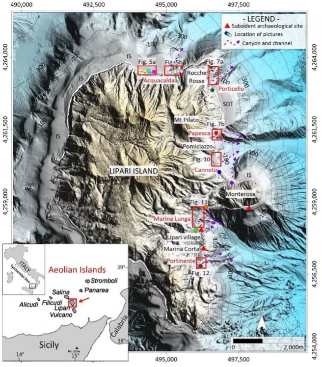
High-resolution digital elevation model of Lipari Island and offshore sectors (contour depths in meters), with location of the coastal areas under study. Red boxes and color dots represent the areas of the maps and the location of the pictures reported in the following figures, respectively. Red triangles represent the location of subsident historical–archaeological sites (see text for details). The position of the main canyon and channel heads affecting the eastern coastal area of Lipari in shallow water is also indicated, together with that of other submarine features cited in the text (IS: insular shelf, SDT: submarine depositional terrace). In the inset: location of the Aeolian Islands in the southern Tyrrhenian Sea.

How to cite and download the publication:

Romagnoli, C.; Bosman, A.; Casalbore, D.; Anzidei, M.; Doumaz, F.; Bonaventura, F.; Meli, M.; Verdirame, C. Coastal Erosion and Flooding Threaten Low-Lying Coastal Tracts at Lipari (Aeolian Islands, Italy). Remote Sens. 2022, 14, 2960. https://doi.org/10.3390/rs14132960